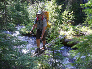
Anaconda was a restful town. We stayed for two nights to recover from the road walk we had walking into town. The highlight of the town was definitely the large community slide (see pic). We slid down it over and over like little kids, it was fun. Anyway, from Anaconda we road walked along the highway in some, finally, hot weather. We had been blessed by sun in the forecast, which we must admit is nicer than being cold in high elevation thunder storms. The terrain in the Anaconda-Pintler Wilderness (see pic) was vastly different from what we had seen before Anaconda. The wilderness was full of 9000 foot passes and beautiful peaks and alpine lakes. It was an area only second to Glacier National Park, in beauty. Our second day out we decided we would bust out a 24 mile day which included 8000 feet of elevation gain over the four passes we climbed that day. Our goal was make it to Warren Lake (see pic), which was described in our guide book as a "gem". We made it and didn't even have the energy to make dinner, but it felt so good to make the miles. With the weather being so hot, the mosquitoes were as blood thirsty as ever. Brian and I had to wear long sleeve shirts and pants through the burned forests in 85 degree heat, it was fun! The terrain mellowed out as we made our way out of the Anaconda Pintler area to the Beaverhead/Deer Lodge Forests. We eventually made it to the Idaho border at Chief Joseph Pass. We were blessed to run into a wonderful couple named, Jim and Rexine (see pic). They took us back to their camp where they were the camp hosts for the summer. We got to soak in the amazing hot springs (see pic) next to the camp and come back to a wonderful home cooked meal. They were truly tail angels! From the Idaho border we departed to Bozeman, MT for one of two weddings. Next we are off to Homer, AK for another wedding. We will return to the trail at the same location on August 6th when we will resume our hike and head out to Bannock Pass in Idaho.
Wednesday, July 29, 2009
Wednesday, July 15, 2009
Helena to Anaconda
This section took us through, prospect land, lodge pole forest and rolling hills. It was short but like the other sections it still offered its share of challenges. Weather continued to be a concern with daily thunder and lightning storms and rains that would turn the trails into rivers. The trip to Anaconda also included a jaunt across private land giving us the chance to get charged by an angry cow and to perfect the important skill of navigating through barbed wire fences. We even got to sleep in a ditch. So goes the CDT. From here we head off into the Anaconda Pintler wilderness; our last leg before we head off the trail to attend some wedding celebrations.
Friday, July 10, 2009
Rogers Pass to MacDonald Pass (Helena, MT)
This section can be summed up with one word, weather. The terrain was not that difficult but walking while it is pouring rain and blowing it in your face is hard, especially with lightening striking all around you. Basically our routine was to walk in the sun for the first few hours of the day and then at 1pm sharp a huge thunder head would start dumping on us. We also had our first couple days of 20 milers which were tough on the feet. At least our bodies are just now starting to get use to what we are doing to them. We also got our first opportunity to mingle with the local cattle population. Cows are actually really scary when you get up close to them, and they give really mean stares. Brian also got to see a bobcat on our last day in the section, too bad it was faster than our camera. When we finally made it to MacDonald Pass we were greeted by Uncle Wally who had Coke and ice cream waiting for us. Gosh he really knows the way to a thru hikers heart.
Benchmark to Roger's Pass (Lincoln, MT)
In this section we were trying to get through it as fast as possible to make it to our next town, Lincoln, MT. We had already been on the trail for 7 days from East Glacier, and we had 3 more days ahead of us. But of course, the weather had other plans for us. We hiked out of Benchmark in areas that were marked by fires from 1989. We wondered through matchstick forests over increasingly larger passes. We finally got our chance to camp/walk directly on the divide, which is so incredibly breathtaking. We were, however, held up one day when we found ourselves at 7000 feet in the middle of a huge lightening/thunder/hail/rain storm. We huddled in the small trees to try and escape the hail for ~30 minutes. Then we got smart and ran for cover about 200 feet downhill and set up our tent to wait out the storm and dry off. The storm didn't pass until late evening so we hoped for the best the next day. Turns out we got our sun and it was a very good thing because we still had 2000 feet of elevation to gain that day. We climbed our first major summit, Caribou Peak, reaching over 8900 feet. We also found that while the the views were beautiful from the divide, they lacked one thing, WATER! This issue of no water sources would prove to be a problem for miles to come.
East Glacier to Benchmark
First of all we wanted to go ahead and thank all of our family and friends for your continued support. All of your kind messages, conversations, and remarks are what help fuel us to continue hiking.
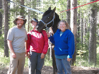
From East Glacier we set off on a journey into one of the most remote parts of our hike. This area is know offically as The Bob Marshall Wilderness, but we call it the "Bob". The Bob was 120 miles of probably some of the most challenging terrain we will see on the trail. It was to be described as pure bliss and brutality. We hiked out of East Glacier to just pass Highway 2. The northern part of the section was primarily a web of jeep roads and stream/river crossings. Can we say wet feet! The weather in the beginning was beautiful, we had several bluebird days that made for some pleasant hiking. We made our way South slowly. The terrain was very rugged especially as we approached the "gem" of the Bob, the "Chinese Wall". When traveling below the wall we spent about 6 miles post holing in snow and bushwacking through all of the avy debris that had rocked the area in the winter. We finally made it into horse country as we approached Benchmark, one of our resupply locations. We encountered many of Montana cowboys in this area. When we got into Benchmark we were a little turned around and a friendly cowgirl named Susan (see picture) befriended us. She drove us to the Benchmark Wilderness ranch to p/u our box of food and then took us back to her camp where she gave us a cold Coke (YUM!), and we got to meet her horse "Bronzy". Bronzy was a beautiful Tennesse Walker who liked nibble at the salt on our shirts (as seen in the picture). From Benchmark we headed down the trail a few miles and pitched camp for the night.
Subscribe to:
Posts (Atom)